Dyfi Forest Resource Plan
Location and setting
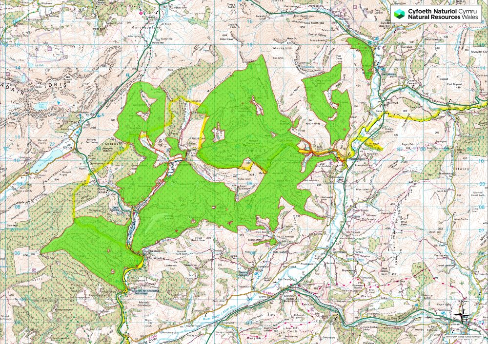
Dyfi forest is situated to the north and west of the Afon Dyfi. It includes the forest areas known as Pantperthog, Hengae, The Dulas Valley, Dyfi North, Dyfi South, Ty Mawr and Dinas Mawddwy. Total area 5016ha. It is situated within two planning authorities of Powys to the south and east, and Gwynedd including Snowdonia National Park to the north and west.
Visually, large areas of the forest are hidden but certain sections such as the Dulas Valley is highly prominent and can be seen from communities along the valley, mainly Ceinws, Corris Uchaf, Corris Isaf, and Aberllefenni, and by users of the A487. Some of the uppermost northern edges are seen from Cadair Idris, to the north. Other communities that are visually impacted by these woodlands are Dinas Mawddwy to the north east and Aberangell further south on the eastern exit from the main Dyfi forest block.
All of the forest is within the Afon Dyfi water catchment. The terrain in Dyfi is very dramatic with many steams leading into the Afon Dulas and Afon Dyfi. The forests are increasingly diverse with much of the area now in second rotation with an on-going program to improve riparian and native woodland habitats.
Dyfi North and South, the main central block between the Dulas Valley and Aberangell, is nearly 3000ha and typified by steep sided rolling hills with restructured conifer plantations which are mostly in second rotation and an improving network of riparian and native woodland habitat.
Ty Mawr
Ty Mawr block is largely hidden within the Afon Mynach valley to the north of Aberangell with the exception of its eastern upper-edge which is seen from the A470, though much amelioration work has already been done to remove trees from the ridgeline.
Pantperthog
Pantperthog is to the west of the Afon Dulas and is largely hidden but does rise up towards the Tarren y Gesail ridge. It is bordered on three sides by privately managed forest. It is mainly conifer plantation in second rotation with an improved network of riparian habitats and broadleaf planting.
Dinas Mawddwy
The Dinas Mawddwy block though relatively small (122ha) has a visually dominant position alongside the A470 trunk and the surrounding countryside as well as the village of the same name to the east.
Hengae
Hengae is again typically steep and within an enclosed valley (Afon LLefenni) to the north of the village of Aberllefenni. It climbs up to the Mynydd Fronfraith ridge and adjoins private woodland along its eastern edge south of Mynydd y Waun.
The Dulas Valley
The Dulas Valley is considered the area following the Afon Dulas up to Aberllefenni. It has some of the most difficult steep terrain and dominates the villages of Ceinws, Corris and Aberllefenni.
Summary of objectives
The following management objectives have been agreed in order to maintain and enhance the resilience of ecosystems, and the benefits they provide:
- Increase diversification of the forest tree species composition from what is currently spruce dominated, in order to increase resilience to pests and disease whilst improving resilience to climate change.
- Look at all opportunities to increase structural diversity within stands through utilising a variety Low Impact Silvicultural Systems (LISS) where appropriate. The type of silvicultural system will be constrained in large areas due to steep ground, lack of previous thinning and exposure on the highest ground.
- Maximise thinning, particularly ensuring first-thinning is done on time and frequently thereafter. This will improve ecological diversity and increase options for future management including possible use of LISS.
- Improve age diversity through clear-felling programmes which will continue to maximise age diversity both within catchments and across the wider forest area.
- Create a diverse permanent forest structure and ecosystem that includes riparian and native woodland, natural reserves, long-term retentions, successional woodland and a mosaic of open habitats including forest roads and rides. Allow for a variety of woodland management regimes where natural processes only take place. This will not only benefit forest structure but will also provide important permanent habitat for a variety of fauna and flora such as Goshawk nest sites and lichen habitats.
- Increase the use of natural regeneration in establishment of new crops where appropriate, particularly native broadleaf species but also conifers on LISS sites
- Continue to be a highly productive forest for timber production, utilising as much as possible a diversity of tree species that will flourish both now and into the future according to climate change predictions and should continue to maintain a regular sustainable supply of quality timber products.
- Continue to explore the potential for any renewable energy projects within the forest area, which includes ongoing support for Hydro schemes in Pantperthog.
- Look for opportunities for supporting local business’s, local marketing of timber and for increased employment directly or indirectly both in timber production and other activities/businesses related to activities within the forest.
- Invest in a permanent infrastructure of roading and tracks to develop access to areas where it does not exist and to help develop internal infrastructure for future LISS sites to ensure long-term management of the whole forest.
- Utilise the watercourses, existing native woodland habitats, upland open habitats as the basis of a permanent forest structure, creating larger habitat networks with improved linkages with ancient woodland, such as the Coed Maes Mawr SSSI. Also link open habitats such as Fron Felen and the heathland habitat above the forest. This linked network of riparian and native woodland will improve water quality and enhance biodiversity.
- Protect and enhance microclimatic conditions for Lichens in Cwm Gleswych, Cwm Ceirig and Cwm Llecoediog. Management and prioritising areas for Lichens habitat improvement should be linked to the improvements in riparian, ancient woodland and new native woodland.
- Develop a prioritised programme of removal of Invasive Non-Native Species (INNS) from riparian zones, native woodland habitats and all other parts of Dyfi Forest.
- Urgent removal of mature Western hemlock to be prioritised through clear-felling programmes. Younger Western hemlock removal must also form part of riparian improvement work and restock site preparation, cleaning and respacing programs.
- Protect and enhance the ecological condition and features of the Ancient Semi-Natural Woodland. Improve the condition of all Planted Ancient Woodland Sites with linkages between ancient woodland, existing and new native woodland, to improve habitat networks.
- Protect and enhance the condition of the Coed Maes Mawr SSSI, improve its connectivity to the wider native woodland habitats within and surrounding Dyfi Forest.
- Create an appropriate plan to protect and manage the Cadair Idris SAC / SSSI heathland habitat which includes, the removal of planted conifers within the SAC/SSSI, the creation of an upland native woodland habitat, new open space linked to deep peat restoration and removal of none native species from the designated areas between forest and heathland.
- Create or enhance open space in other areas of recently identified for deep peat restoration, possibly linking with open upland habitat and the Cadair Idris SAC.
- Increase the opportunities for deadwood habitat through identifying Long-term Retentions, Natural Reserves and by changing operational habits. Leaving deadwood in situ supports a diverse biota within the forest ecosystem.
- Improve habitats for the range of important fauna currently within Dyfi. This includes, Otters, recently introduced Pine Martins, Goshawk and Dyfi Forest is particularly noted for its Dormice population, management activities should look to improve and expand Dormice habitat.
- Reduce the potential for flood risk by riparian habitat improvement, maintaining woodland cover and expansion of the native woodland area. By managing the extent of clear-fells within catchments and thinning crops whilst maximising the use of LISS, this will minimise the impact on peak water flows and also critical loads in acid sensitive catchments.
- Minimise the potential adverse effects of acidification through maintaining good and improved water quality through improved riparian habitat and linkages, increased area of native woodland and improved habitat networks based on the riparian infrastructure.
- Improve the visual diversity of the forest by increasing the structural diversity and species diversity within and between stands and increased native woodland and riparian habitats.
- Protect and enhance the numerous important historical features which include abandoned slate quarries, old farmsteads, and slate fencing, either with open space or native woodland expansion. Link them with recreational routes or other habitat networks where possible.
- Maintain existing recreational facilities to a high standard and look to develop appropriate recreational opportunities in the forest.
- Maintain Public Rights of Way and ensure they are taken into account during operational activities and any blockages are reinstated as necessary.
- Maintain and improve current links with local communities to ensure current levels of access and usage are in line with local needs as well as other activities such as motor rallies, enduros and horse events.
- Protect and improve access along the walking trails that link up to the Tarren Hendre long distance route running from Corris to Tywyn, with links from Abergynolwyn, Pennal, Corris and Dolgoch.
Location Map
Maps
Forest management and felling strategy map