
Alwen Reservoir, near Denbigh
Walk or cycle around this huge upland reservoir

Discover the heritage features tucked away amongst the trees and our information panels about the people who once lived and worked here.
The woodland provides an excellent habitat for wildlife – look out for birds such as buzzards, goldcrests and coal tits.
The small lake known as Llyn Ochin has dried up but this marshy area now attracts dragonflies and newts, and plants like cotton grass thrive here.
The trail may be used by walkers, cyclists and horse riders and it is waymarked so that walkers follow the route in a different direction to cyclists and horse riders.
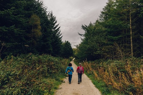
The walking trail is waymarked from start to finish.
Look out for the information panel at the start of the trail.
Find out about walking trail grades.
The walking trail sets off on a wide track through the iron gates at the woodland entrance and then turns left onto a path through the woodland.
Look out for ruined buildings from a 19th century lead mine, the remains of a shepherd’s cottage with a walled meadow full of wildflowers in summer and a newly replanted orchard.
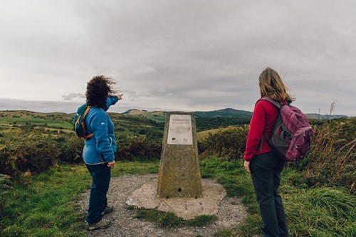
At the end of the trail there is an optional climb to a trig point from where you can enjoy views of the Jubilee Tower at the top of Moel Famau and the Dee Estuary.
All our mountain bike trails are waymarked from start to finish and have been graded for difficulty.
At the start of the trail there is an information panel – please read this before setting off.
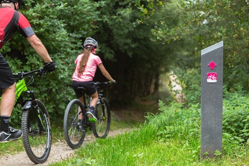
This cycle trail is a great place for families to safely enjoy cycling away from busy roads, and at the same time learn about the woodland’s varied history.
The wide track from the iron gates at the woodland entrance meanders through the forest, avoiding major climbs and offering spectacular views over the Cheshire Plain and beyond.
There are several public footpaths from the Coed Nercwys car park.
See the information panel in the car park for a suggested route to Bryn Alyn, the second largest limestone pavement in Wales (moderate, 4 miles/6.3 kilometres).
This route may not be waymarked and we recommend that you take a map with you.
Coed Nercwys is situated in the Clwydian Range and Dee Valley Area of Outstanding Natural Beauty (AONB).
The Clywdian Range is a chain of purple heather-clad summits topped by hillforts. The Dee Valley lies beyond these windswept hills and is home to the historic towns of Llangollen and Corwen.
For more information about visiting the AONB go to the Clwydian Range and Dee Valley website.
Coed Nercwys forms part of the National Forest for Wales.
The National Forest will:
It will form a connected ecological network running throughout Wales, bringing social, economic and environmental benefits.
Parts of the network will eventually form a trail running the length and breadth of Wales, so anyone can access it wherever they live.
For more information go to the National Forest for Wales website.
We want you to return home safely after your visit here.
You are responsible for your own safety as well as the safety of any children and animals with you during your visit.
For advice and tips to help you plan your visit here go to Visiting our places safely.
See the top of this webpage for details of any planned closures or other changes to visitor facilities here.
For your safety, always follow instructions from staff and signs including those for trail diversions or closures.
We may divert or close trails whilst we undertake maintenance work or other operations and we may need to close other visitor facilities temporarily.
In extreme weather, we may close facilities at short notice due to the risk of injury to visitors and staff.
Coed Nercwys is 4 miles south west of Mold.
The postcode is CH7 4DD.
Please note that this postcode may not take you to the car park if you use a sat nav or navigation app.
We suggest you follow the directions below or use the Google map on this page which has a pin on the car park’s location.
Head south from Mold, following signs for Nercwys.
Continue through Nercwys and at the second set of crossroads, turn left onto Ffordd Cae Newydd.
After around ¾ mile take the first right and continue for 250 metres and the car park is on the left.
View this place on the What3Words website.
The Ordnance Survey (OS) grid reference for the car park is SJ 218 592 (Explorer Map 265).
The nearest mainline railway station is in Buckley.
For details of public transport go to the Traveline Cymru website.
Parking is free of charge.
Overnight parking is not permitted.
There are no staff at this location.
Contact our customer team for general enquiries during office hours, Monday to Friday.


