
Beddgelert Forest, near Beddgelert
Huge forest in the heart of Eryri National Park
Controls 6 and 7 on the orange orienteering course are closed due to a damaged footbridge. Please turn around at control 5 and continue to control 8.
Gwydir Forest Park surrounds Betws-y-coed, one of the prettiest villages in Eryri National Park.
Our waymarked walking trails set off from the village and include an easy boardwalk stroll, steep climbs up forested hillsides with far-reaching views, and walks around beautiful lakes.
Look out for our information panels in Pont y Pair car park or buy a walking guide from the Eryri National Park Information Centre in the village centre.
The public toilets in the Pont y Pair car park are managed by Conwy County Borough Council and there is a charge to use them.
The permanent orienteering course begins just outside Betws-y-coed and finishes in the centre of the village.
The walking trails are waymarked from start to finish.
They start from the Pont y Pair car park in the centre of Betws-y-coed (apart from the Llyn Elsi Walk which starts behind St Mary’s Church).
Look out for the information panel at the start of the trails.
Find out about walking trail grades.

Take this short, easy walk, under tall and majestic Douglas fir trees - some are up to 100 years old.
Find the signs along the trail to discover facts about the trees.
You can also pick up a leaflet at the start of the path for the Animal Discovery Trail or you can download a copy from the bottom of this page.
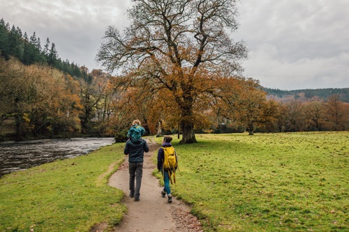
Walk out alongside the river through the tall Douglas firs and onto the flood plain with views of the surrounding hills and forests.
You’ll find an interpretation panel at the Miners’ Bridge explaining why it was built there and how it got its name.

Follow the trail up the steep hillside, resting at a cliff-top viewpoint overlooking the valley.
At the top of the hill you will reach Llyn Parc, a natural lake that was dammed to power mining machinery in the Aberllyn gorge below.
The trail descends through the gorge passing several mine entrances and the ruins of mine structures.

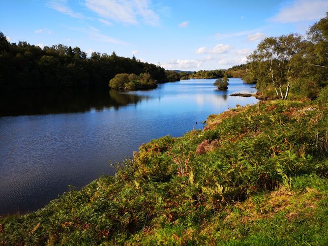
Leave the bustle of Betws-y-coed to discover a tranquil and scenic lake.
The scenery, wildlife and peaceful atmosphere as you walk around Llyn Elsi are really worth the hike up from the village.
Follow the path around the lake as it cuts in and out from the water’s edge until you join the main path to re-trace your steps back to Betws-y-coed.
The Orange Course, a permanent orienteering course through Gwydir Forest Park, begins just outside Betws-y-coed and finishes in the centre of the village.
It was designed by Eryri Orienteers and is graded to British Orienteering Federation standards.
Test your map-reading skills by navigating between the 10 wooden marker posts on this permanent orienteering course in Gwydir Forest Park.

Gwydir Forest Park lies in the heart of the Eryri National Park and encircles the village of Betws-y-coed.
Lead and zinc mining once dominated the area and the legacy of old engine-houses, waste tips and reservoirs are characteristic features of the forest landscape today.
Several of the most important mines have been partially restored and made safe for visitors.
In addition to the walks from Betws-y-coed, waymarked trails start from several other Natural Resources Wales car parks in Gwydir Forest Park:
Gwydir Forest Park is set in Eryri National Park.
Eryri is the largest National Park in Wales and is home to picturesque towns and villages and the highest mountain in Wales.
It is looked after by the Eryri National Park Authority.
For more information about visiting Eryri go to the Eryri National Park Authority website.
We want you to return home safely after your visit here.
You are responsible for your own safety as well as the safety of any children and animals with you during your visit.
For advice and tips to help you plan your visit here go to Visiting our places safely.
See the top of this webpage for details of any planned closures or other changes to the trails here.
For your safety, always follow instructions from staff and signs including those for trail diversions or closures.
We may divert or close trails whilst we undertake maintenance work or other operations and we may need to close other visitor facilities temporarily.
In extreme weather, we may close facilities at short notice due to the risk of injury to visitors and staff.
You may need permission from us to organise an event or to carry out some activities on our land.
Check if you are allowed to use our land.
We recommend you follow these directions or use the Google map below which has a pin on this place’s location.
Follow the A5 through Betws-y-coed village centre and turn onto the B5106 signposted to Trefriw.
Go over a stone bridge and turn immediately left onto a minor road.
After 50 metres the Pont y Pair car park is on the right.
The walking trails start from the Pont y Pair car park (except the Llyn Elsi Trail).
The Llyn Elsi Trail starts behind St Mary’s Church in the centre of Betws-y-coed, five minutes walk from Pont y Pair car park.
The Ordnance Survey (OS) grid reference for Pont y Pair car park is SH 791 567. (Explorer Map OL 17).
The postcode is LL24 0BL. Please note that this postcode covers a wide area and will not take you directly to the entrance.
View this place on the What3Words website.
The nearest mainline railway station is in Betws-y-coed.
For details of public transport go to the Traveline Cymru website.
The walking trails start from the Pont y Pair car park in Betws-y-coed.
Pont y Pair car park is operated by Conwy County Borough Council.
There is a parking charge.
There are no staff at this location.
Contact our customer team for general enquiries during office hours, Monday to Friday.


